
New to Van Dwelling? These maps will point in you in the best direction, for you. #vanlife
New to Van Dwelling? These maps will point in you in the best direction, for you. #vanlife
 “Where do all these Highways go, now that we are free?”-Leonard Cohen.
You can go and spend time anywhere in the country in your van or RV. Where should you go? America has as many variations in landscape and culture, as you can imagine. Here we will map out the lines which divide the different landscapes and the different cultures in America. We will also look at the paths through and across those divides.
Those who are ignorant of their country’s geography are doom to be perpetually stuck “kicking around on a piece of ground in their hometown,” not knowing there are many other places to go, which are all new and exciting, and all look different.
Besides using Google Maps, I used the following maps:
http://www.learnnc.org/lp/media/uploads/2010/03/us_precip.gif
http://hint.fm/wind/
http://blogs.gordon.edu/curry/files/2015/06/FedLndOwn-1mgu9ub.jpg
http://demographics.virginia.edu/DotMap/
http://darksitefinder.com/maps/world.html
http://www.colinwoodard.com/files/ColinWoodard_AmericanNations_map.pdf
Main Places I talk about each map:
1:06 Precipitation Map of US
2:46 Live Wind Map
3:49 Public Land Map
6:09 Racial Dot Map
7:10 Dark Sky Map
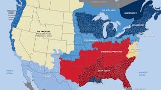
9:38 American Nations Map
Im from St Louis also still living in St Charles Missouri though
Much wiser to do research before hitting the road, and I appreciated this video very much. I’ve been curious about BLM land in my home state, and you led me right to the info! Thank you!
Nice presentation.
Too bad the audio is so low
Main Places I talk about each map:
1:06 Precipitation Map of US
2:46 Live Wind Map
3:49 Public Land Map
6:09 Racial Dot Map
7:10 Dark Sky Map
9:38 American Nations Map
I really like this. I’ve never seen maps before that show all this detail… I’ll be saving your video for later reference 🙂 Thank you. Happy travels!
I have a fun fact for you. There’s a spot on the Olympic Peninsula of Washington State that is VERY dry!! In the Northeast corner of the peninsula, at a town called Sequim, it only rains about 13 inches a year. Yet you can drive 2 hours to a rain forest on the west side of the peninsula where it rains over 120 inches a year!!
Love the video. I am a map freak also. Maps and weather.
COULD HARDLY HEAR YOU
If you’re out here on the interstate system you need to have a motor carrier atlas. I seen so many people who had no idea of the difference in temperature of different highways at certain times of the year
Very interesting John, thanks
Nice Job
Thanks! I LOVE maps and they’ve helped me find some very cool spots over the years. I’m a future vanner, too, and these will supplement my planning a great deal…
Very interesting, but wish the volume was a little louder. Thank you for posting.
Cool video I really appreciated that.
Here’s my rustic cabin van build might give you some ideas if you do the van life
https://youtu.be/HR7fdNS7Otw
Love your maps very interesting..thanks
Thank you for your research, really interesting, I’ll be back on the road in a van very soon and I am going to get much deeper into this. I am intrigued by dialects or accents, which I think change noticeably every 30 to 50 miles. your work puts another layer on this. Subbed and rang the bell, I’ll share my further research with you, as I travel.
Volume low.
To better understand the Ohio area, do a Google search of "The Toledo War".
Good job on the maps. I full-time RV, One other thing, Lindbergh 75 how about you? You know what I’m talking about. 🙂
Not a van dweller but loved the video..thanks
"van curious" lmao
Maps? I was born with a map in one hand and a flashlight in the other! Yes water is a "magical" thing in the desert! Thanks, I found out the panhandle of Idaho is not so dry.
very interesting, tfs
Damn, thanks for making this video this is great insight
Really good stuff
I’m from St. Louis too
I live in the extreme NE corner of Ohio, this area is called the Western Reserve just like you mentioned and the architecture and attitudes are very Yankee. In fact our county seat, Jefferson, Ohio has been called a very New England feeling town.
It’s not stupid to love maps, I have loved maps since I was about 2 years old and I got a giant us shape puzzle map.. I was hooked! My brother too😀I traveled with a carnival years ago and it was super hot, hard work and I have fair skin and red hair and freckles.. I always wore a head cover, long pants and long sleeves..we worked in the hot sun and everyone would sweat and would be wringing wet, but I be cool while the shirtless people would be hot and miserable.. also, I avoided burning my delicate skin.. hehehe
i love maps too..
Great video. Have been looking for something like this as I’m giving this a serious thought to be a full time van dweller soon.
Hey John, on the precipitation map, was the white strip from MN to TX tornado alley?
I actually found those maps fascinating! I majored in demography, (not cartography!) but there are some similarities. Your maps incorporate a lot of demography. I’m van curious too, and I’m saving your maps!